
The Paratebueno earthquake triggered a landslide in 60 hectares near the Cumaral highway: Geological Survey

In response to reports of the damage caused by the 6.5 Mw magnitude earthquake recorded on June 8, with its epicenter in Paratebueno, Cundinamarca , an interdisciplinary team from the Colombian Geological Service (SGC) traveled to the area on June 9 to verify and document the effects of the earthquake on the ground and evaluate possible risk scenarios arising from the event.
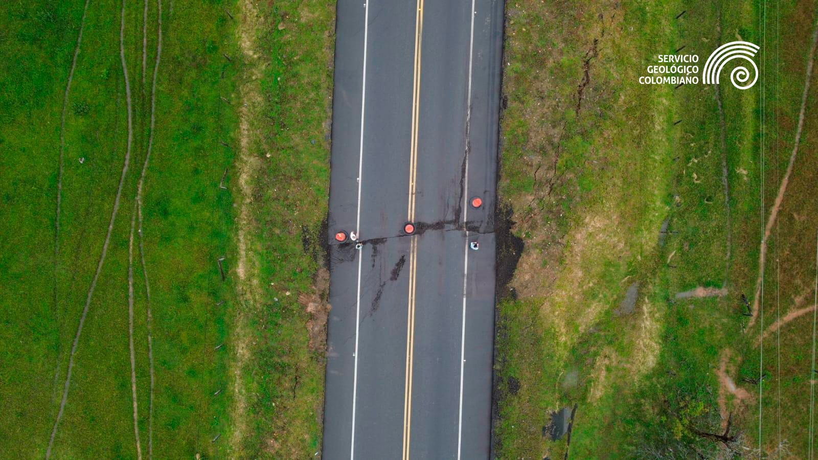
Since then, the SGC has been carrying out key actions such as assessing the damage to the municipality's infrastructure and its surroundings, estimating the intensity of the earthquake, identifying recent landslides, installing new speed and acceleration sensors at two strategic points near the epicenter, as well as conducting overflights with drones equipped with RGB sensors and LiDAR technology, in order to identify whether the cracks observed in videos and images correspond to direct surface ruptures (primary effects of the earthquake) or to cracking induced by the shaking in soft ground (secondary effects).
"These measures seek to strengthen instrumental coverage in the area, improve the capacity to detect and locate aftershocks, and provide reliable technical information on the evolution of the phenomenon. Over the past six days, technical advances have been continuously shared in Unified Command Post (PMU) sessions with other entities of the National Disaster Risk Management System, so that authorities and decision-makers can act in a timely manner," the SGC stated.
A SGC team is in the area, assessing the geological conditions of the epicentral region. Photo: SGC
Thanks to information reported by the rural community of Paratebueno, the SGC began assessing a landslide in the Naguaya canal basin, located in the La Europa area , which, according to witnesses, occurred at 4:00 p.m. on June 8.
The SGC explains that a landslide is the displacement of material—such as rock, soil, debris, and vegetation—due to the action of gravity. Material moves downslope from a higher elevation to a lower elevation, primarily due to the influx of rainwater or groundwater, earthquakes, or human activities such as slope clearing or deforestation, which change the properties of the materials, making them more susceptible to movement.
The technical team identified it as a translational landslide that completely blocked the Grande channel—whose channel has been lost—and partially affected the Naguaya channel.
The landslide, with a magnitude equivalent to 100 football fields, has a maximum width of 380 meters , measured at the crest (initial zone of the detachment), and an approximate length of 1.5 kilometers from the crest to the toe (lower zone where the displaced material accumulates). To date, a scarp (a bare wall of rock or soil devoid of vegetation) approximately 60 meters high has been identified, demonstrating the magnitude of the event.
The displaced mass caused damage to the rural road leading to the municipality of Medina and affected the stability of power poles located at the top, near the crest. In addition, hundreds of trees were downed over an area of approximately 70 hectares, some of which fell on nearby homes.
Although no emergencies have been reported so far, the SGC warns of potential risk scenarios for the population. "The partial blockage of the Naguaya Canal could generate water dams that, if ruptured, could trigger debris flows capable of affecting areas located downstream," the agency's experts indicate.
As a preventive measure, the SGC has proposed a 634-hectare evacuation zone, which may be adjusted based on new information collected in the field. It also recommends establishing effective communication channels with communities, restricting the presence of people and vehicles in critical areas during rainfall events, installing signage indicating areas under observation, and considering the possibility of controlled discharges from temporary reservoirs through pipelines directed downstream of the obstruction point.
In addition to this landslide in the La Europa area, the SGC technical team has identified other instability processes on neighboring slopes , which are being mapped, georeferenced, and analyzed as part of a comprehensive assessment of the terrain's behavior in this area of eastern Cundinamarca.
SGC technical team assessing the effects of the earthquake. Photo: SGC
Additionally, the SGC is advancing the assessment of the earthquake's effects to estimate its intensity, gathering information through community interviews about damage to homes, infrastructure, and environmental disturbances. So far, significant damage has been documented in the Santa Cecilia district, including collapsed homes, the local school, the church, and other essential services.
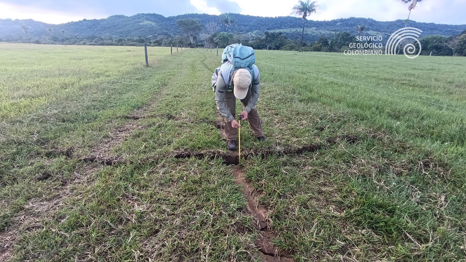
In parallel, crack mapping is being carried out, measuring their direction, length, and amplitude, which provides key data for characterizing the earthquake.
On the other hand, the SGC has installed four seismic monitoring devices in the Mararabe district in the municipality of Paratebueno and in the San Pedro de Jagua district in the municipality of Ubalá. The purpose of this installation is to monitor recently generated aftershocks, obtain more detailed information on seismic activity in the area, refine regional geological models, and increase the reliability of locating future events.
“The SGC continues on the ground evaluating and analyzing signs, changes, clues, and tracking deformations to understand how the ground responded to this earthquake, one of the largest in this region in recent years. We urge the community to seek information through the official communication channels of the entities that comprise the National Disaster Risk Management System and to avoid disseminating information whose source has not been verified, while authorities advance in monitoring, analysis, and institutional coordination,” said Julio Fierro Morales, Director General of the Colombian Geological Service.
eltiempo


